Mil Ventanas Güímar: Rock-Cut Tunnels, the Old Excavator and Views Across the Valley
Mil Ventanas is one of Tenerife’s most distinctive mountain landscapes: an old water channel threaded through cliffs, with tunnels opening onto the steep ravines above Güímar. Also known as Ventanas de Güímar or Canal de los Mil, it combines remarkable engineering, dramatic views and memorable landmarks, including the wrecked excavator beside the channel.
In this guide
Where is Mil Ventanas in Güímar?
Mil Ventanas lies in the mountains above Güímar, on the eastern side of Tenerife. Its best-known passages cross the steep upper slopes around Barranco de Badajoz, where the channel cuts through rock faces and follows the contours between ravines. Anocheza is the upper approach area most frequently mentioned in route descriptions.
The setting is substantially higher than Güímar town. Around the thousand-metre elevation band, cultivated lower slopes give way to rugged mountainsides, scrub and patches of pine woodland. Views open towards the valley and, when visibility allows, the Atlantic coast.
The names Mil Ventanas, Ventanas de Güímar and Canal de los Mil generally refer to the same celebrated channel landscape. However, a walk described simply as “Barranco de Badajoz” may remain on the ravine floor and never reach the windows above it. Check the actual course of an itinerary rather than relying on its title.
The water channel and the purpose of its windows
The channel belongs to the extensive network of water infrastructure that helped shape Tenerife’s agricultural landscape. Moving water across steep volcanic terrain required carefully aligned channels, excavated passages and considerable manual labour.
Here, the alignment passes through projecting rock faces instead of repeatedly climbing over them or descending into every hollow. Open stretches alternate with tunnels, maintaining the channel’s course across a mountainside that offers few easy lines of passage.
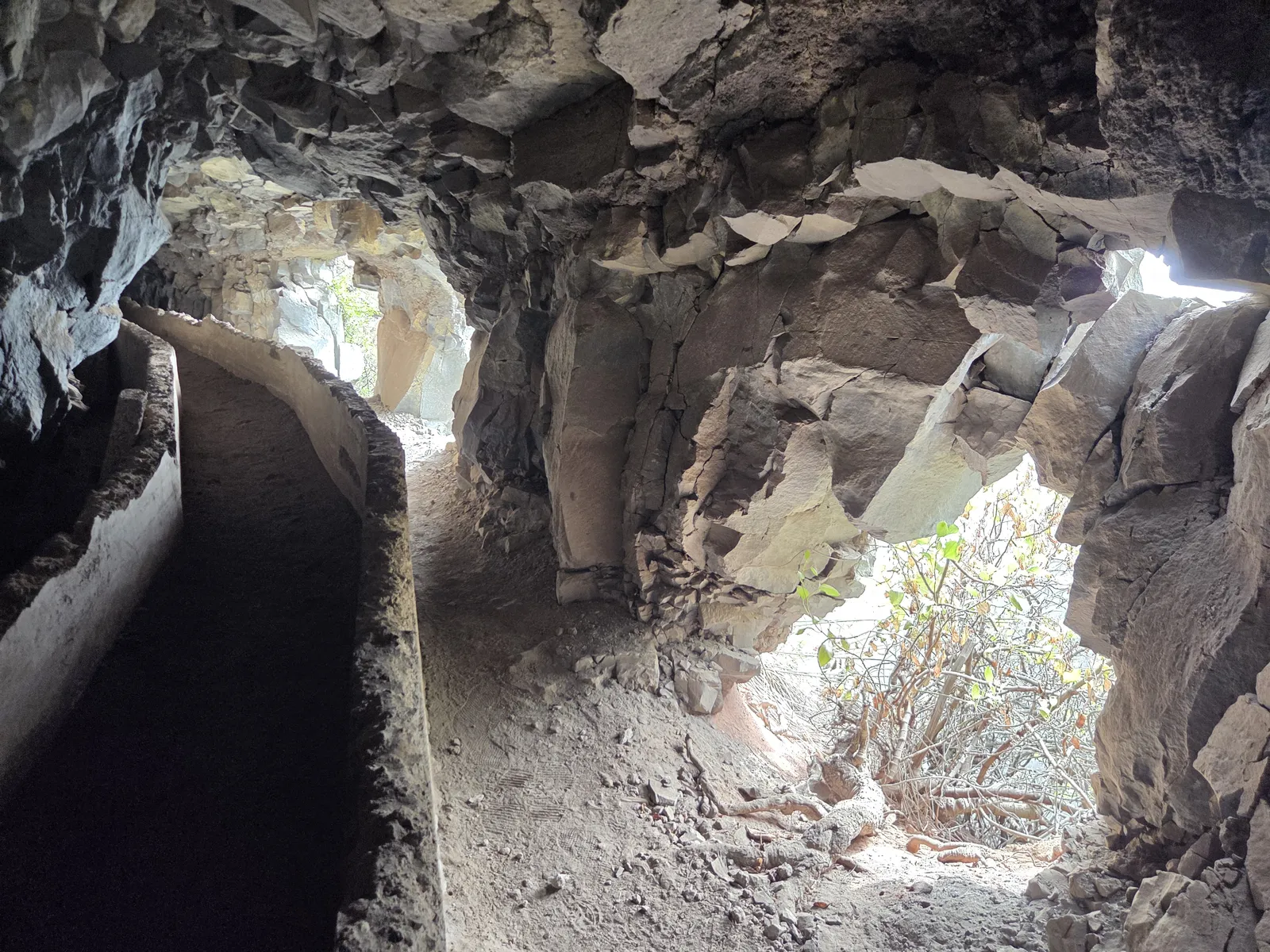
The windows are openings cut through the outer tunnel wall. They provided places to remove excavated rock and allowed daylight and air into the interior. Today, they frame the surrounding slopes and create the feature for which the location is best known.
“A thousand windows” is a popular name rather than an exact inventory. The most interesting detail is their relationship with the channel: from inside, each opening provides a brief view out; from across the ravine, the openings reveal the engineering line running through an apparently continuous cliff.
What the tunnels and mountain scenery are like
The character of Mil Ventanas comes from the repeated change between enclosed rock passages and open mountainside. Inside, rough walls stand close to the channel, with irregular ceilings and stretches of deep shade. Around an opening, the light changes abruptly and the landscape becomes visible beyond the tunnel wall.
The windows are not a continuous balcony. Their size, shape and spacing vary, and some passages remain dark despite nearby openings. This uneven rhythm makes the excavation feel closely connected to the rock through which it was cut.
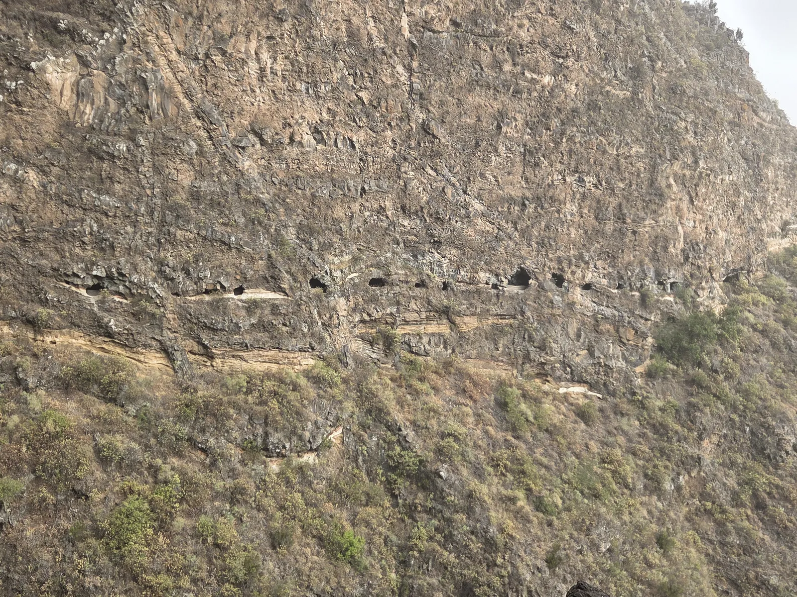
Outside the tunnels, the wider landscape becomes equally important. Layered rock faces, deeply incised gullies and vegetation clinging to the slopes provide a sense of scale that close-up photographs cannot convey. Around Barranco de Badajoz, the terrain is particularly abrupt.
Clear weather brings broader valley views, while cloud and haze produce a more enclosed atmosphere. For photography, the principal challenge is balancing the dark tunnel interior with the bright landscape outside. Take photographs from stable ground, leaving enough space for others to pass without approaching an exposed edge.
The wrecked excavator: a recognisable Mil Ventanas landmark
The old excavator is one of the best-known landmarks associated with Mil Ventanas. Its twisted yellow machinery rests against the vegetated slope beside the channel area, creating an unmistakable contrast with the surrounding rock and scrub.
The wreck is frequently used as a reference point in accounts approaching from Anocheza. Its position near the early tunnel section makes it a memorable part of the landscape, although descriptions can reverse the order of landmarks when following the channel from the opposite direction.
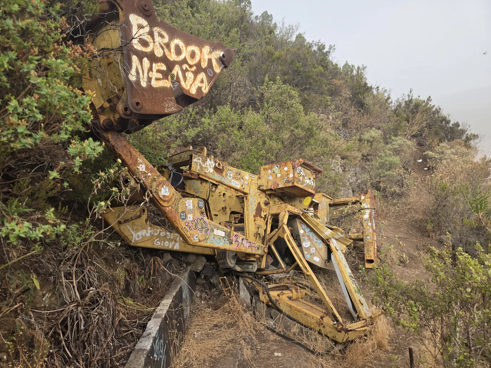
Published accounts describe the machine as having fallen from higher ground. Precise dates and circumstances are less consistently documented, so elaborate stories about the accident deserve caution. The visible wreck itself needs little embellishment: its position conveys the steepness of the setting. Leave the machinery undisturbed and avoid climbing onto its damaged metalwork.
Route options, walking time and difficulty
There is no single standard Mil Ventanas itinerary. Common descriptions include an upper approach through Anocheza, longer walks climbing from Güímar and circuits combining the channel with neighbouring paths and ravines. These involve very different amounts of ascent and walking.
An upper approach reduces the climb from town but still requires a clear plan for the return. Starting in Güímar creates a more substantial mountain outing, with the ascent and descent adding considerably to the channel section. A linear itinerary also needs transport arrangements at both ends.
Compare the starting point, return route and total ascent before accepting a published distance or duration. Tunnel sections can disrupt GPS reception, producing misleading spikes in recorded tracks. Allow generous daylight rather than treating a moving-time estimate as the duration of the whole day.
The main difficulty is the terrain: narrow passages, uneven footing, low rock ceilings, exposed exterior sections and potential falling stones. Strong fitness helps with the climb but does not resolve these challenges. The channel is not a maintained recreational walkway, and it is unsuitable for pushchairs, wheelchairs or a casual outing with young children.
Access, conditions and practical preparation
Access restrictions have been documented at Mil Ventanas, including no-entry signs and warnings published by the Tenerife mountaineering federation. Check the current position with the Ayuntamiento de Güímar before planning a channel visit, and respect signs on the ground. Online tracks describe where people have walked; they do not establish current permission.
For any permitted visit involving the tunnels, a headtorch with spare power is essential; daylight from the windows does not reach every passage. Wear footwear with reliable grip and carry water, food, an offline map and a light weather layer. Keep your hands available for balance.
Choose settled weather and check Tenerife ON for relevant alerts. Rain, strong wind and poor visibility can change conditions considerably. Share your itinerary and expected return time with someone; in an emergency, call 112.
Getting to Güímar and the upper approaches
Güímar is accessible from the TF-1 motorway and the inland TF-28 road. For an approach through Anocheza, establish the exact road and track conditions beforehand: a route’s parking pin does not guarantee a designated public parking area or access suitable for every vehicle. Keep agricultural entrances and service tracks clear.
By public transport, TITSA route 120 connects Santa Cruz with Güímar through Candelaria and Puertito de Güímar. It serves the town rather than the upper channel approach, so account for the additional distance and check the return timetable.
Mil Ventanas deserves attention for the complete landscape: the ingenuity of the channel, the changing light inside its tunnels, the wrecked excavator and the scale of the ravines. Plan around the exact itinerary and confirmed access, leaving time to appreciate those details without rushing.